Importing Spatial Files
Spatial files (also called geo-spatial files) contain location-based data such as points, polygons, and shapes. Zoho Analytics imports spatial files to create customized maps and geographic visualizations.
This page covers the Spatial-specific options. For the general import procedure, plan availability, role permissions, and common settings that apply to all file formats, see Importing Data from Files.
Supported file extensions
| Extension | Description |
| .shp | Shape file |
| .topojson | TopoJSON file |
| .geojson | GeoJSON file |
| .kml | KML file |
Spatial import is available from two file sources: Local Drive and FTP. See Starting an Import on the landing page for source-specific entry steps. Pasted Data is not supported for Spatial files.
Supported geometry types
Zoho Analytics supports the following geo-spatial data types:
- Point - a single location coordinate
- Polygon - a closed shape with multiple coordinates
- Multi-polygon - multiple polygons treated as a single feature
Note: Line and multi-line geometry types are not supported. If your spatial file contains these geometries, a warning message will be displayed during import.
Importing a Spatial file
Spatial import follows the standard procedure described in Starting an Import on the landing page. The Spatial-specific step is the file-type selection:
- After selecting your source (Local Drive or FTP) and providing the source details, the import wizard opens.
- From the File Type dropdown, select Spatial File.
- Click Next to proceed.
- Complete the general settings: First Row Contains Column Names, Format of Date Columns, and any applicable More Settings. These are documented in Configuring Import Settings.
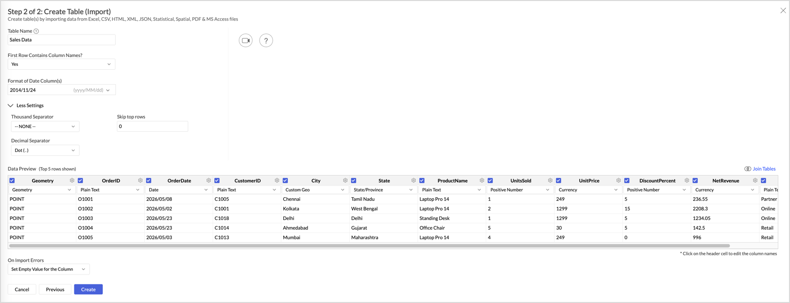
- Review the Data Preview, paying special attention to the Geometry column described in The Geometry column below.
- Configure On Import Errors, then click Create.
The Geometry column
Every spatial file has a Geometry column that contains the location data. Zoho Analytics auto-identifies this column during import based on the file contents.
The Geometry column has the following requirements and restrictions:
- It is mandatory. You cannot import a spatial file without a Geometry column.
- It cannot be deleted from the imported table.
- It cannot be excluded when sharing the spatial table with other users.
- It is restricted to the x-axis of chart views.
- Filter options on the Geometry column are limited to Is Empty and Is Not Empty.
- It is not included in auto-generated reports.
- The geometry data displays only as point, polygon, or multi-polygon. Other geometry types are not represented.
Custom-geo columns
Beyond the Geometry column, Zoho Analytics auto-identifies custom-geo columns in your data. Custom-geo columns contain unique location data, such as district names or city codes, that can be used in place of the Geometry column when creating maps.
For example, if your spatial file has a District Name column, Zoho Analytics recognizes it as a custom-geo column and maps it with the Geometry column for use in geographic visualizations.
Notes and limitations
Spatial tables in Zoho Analytics have several restrictions that do not apply to other file formats:
- File size limit: 15 MB per file. This is smaller than the 100 MB limit for other file formats.
- Data editing: You cannot edit the data in an imported spatial table after import.
- Lookup relationships: You cannot create a lookup relationship using the Geometry column.
- Similar to Another Table feature: This feature is not available for spatial tables.
- Query tables: You cannot create a query table over a spatial table.
- Export format: When you export a spatial table from Zoho Analytics, the exported file is not in spatial format.
- Sharing: When you share a spatial table, you cannot exclude the Geometry column.
Related
- Importing Data from Files - import home page covering source selection, common settings, and operational tasks
- Geo Map Charts - reference for creating maps and geographic visualizations using spatial data
- Import Large Data Files using Zoho Databridge - for very large data files (note: spatial files are limited to 15 MB regardless)